
Services
We turn Arctic Knowledge Into Accessible Digital Solutions
Data platforms, communication tools, mapping services, and collaborative projects designed to support research, outreach, and decision-making across the Arctic.
Design & IT
Interest and awareness about the Arctic and its global importance, economically, environmentally and strategically, is fast rising. The Arctic is estimated to hold as much as 30% of the world's unused resources. Utilization of these resources, strengthening and development of infrastructure, year-round trans-arctic shipping and rapidly increasing tourism requires enormous financial investments, bringing opportunities while posing threats. Environmental awareness is increasing not least due to climate change.
There is a rapidly growing need for access to data and relevant data services, interpreting of data and knowledge based consulting for responsible policy- and decision making.
- Data and Consulting Services and Systems (data collection, processing and storage, statistics, and online data visualization)
- Mapping, Data Systems, Data Management and Analysis (data collection, format conversion, statistical processing, and plotting changes over time and across locations; outputs include statistics, analysis and policy reports, interactive online maps with selectable layers and comparison tools, animations, and tailor-made data packages. ArcData’s web-based GIS system, ADMS, connects and shares map layers through web services and its own GeoServer)
- Consulting Services (expertise covering Arctic statistics; environment and ecosystems, including weather, tides and sea ice; Indigenous peoples; resources and energy, including renewables; infrastructure, including airports and harbours; business and policies; science, observations and projects; knowledge and culture; education; and science communication)
- Virtual Education Systems and Tools (STEM education through Arctic research as a consortium member of Edu-Arctic, plus experience in distance learning and online courses with Edu-Arctic, UArctic, APECS, the International Centre for Reindeer Husbandry and others)
Arctic Maps
Arctic Maps
Arctic Portal specializes in creating customized graphical maps that cover a range of significant Arctic topics with global recognition. These subjects include Arctic Definition, Arctic Sea Ice, Shipping, Governance & Arctic Organizations, Arctic flora, Arctic fauna, and Infrastructure.
We consistently update and add new maps to our website, with recent additions encompassing infrastructure layouts, polar bear population distribution, various whale species distributions, walrus habitats, and Arctic shipping routes featuring projections for Northpolar-Canada and Northpolar-Russia.
All the data employed in crafting our maps are sourced either from our partners (see Arctic Portal Community) or from the most reliable and reputable databases currently available. Our commitment to transparency ensures that sources are consistently cited.
A wide selection of our maps is available for viewing, subject to our specified conditions, and can also be purchased for direct download and can then be used for open publication on the condition that the source Arctic Portal is cited.
If you are looking for a map tailored to your specific requirements, we invite you to submit a request to , detailing your preferences and needs. Our team is dedicated to assisting you in creating a map that aligns perfectly with your specifications, and we will provide cost information accordingly.
To view the available maps please click the following link - Maps Gallery.
Web Hosting
Web hosting
The Arctic Portal hosts various websites for Arctic-related organizations and affiliations. The websites are around 40 and the list is constantly growing.
If you want your website to be hosted by Arctic Portal or if you require any further information, please contact info@arcticportal
Web design & development
Web designing & creating
Arctic Portal designs its websites from scratch, accordingly with the customers’ requirements, and hosts them in its server located in Iceland, a safe and protected server powered by 100% green energy.
We offer continued assistance related to website management, and our IT experts are available to teach you how to independently take care of and update your website.
For further information, please contact
News & information from the Arctic
News & information from the Arctic
Arctic Portal has gathered on its webpage relevant information on the Arctic currently available on the web:
- Daily News On the homepage of www.arcticportal.org, or on our social networks, users may find everyday a piece of news regarding the Polar regions written by our staff. To look for a specific piece of news you want to retrieve from our archive, go to “News” and write the key-words on the title filter. Otherwise, you can just browse all past news. For more updates on what is going on in the region, users may also check out our “News Portlet”, an RSS feed.
- Announcements This section gathers together relevant official communications and/or press releases from both the public and private sector, as Governments, NGOs, Firms, etc., as they have been written by the author/s. If you want to submit your document to be published in this section, please contact . Arctic Portal reserves the rights not to publish the document if considered not pertinent, or offensive.
- Portlets Arctic Portal Portlets provide an easy access to material, as recent news articles, scientific reports and other relevant material, concerning several key topics as “News”, “Climate Change”, “Energy”, “Shipping”, “Arctic Business”, “Fishing” and “Arctic Societies”. The Portlets are co-managed by Arctic Portal in collaboration with several worldwide Institutions with specific focuses on different aspects of the Arctic.
- Library The objective of the Arctic Portal Library is to maintain a comprehensive collection of Arctic relevant scientific and educational material, inclusive of books, articles and journals. The new “legal section” contains the original texts of Arctic-relevant International agreements, International Codes and Regulations and other relevant legal texts. Furthermore, this section also collects relevant quasi-legal instruments, or “Soft-Law” materials, as resolutions, declarations, statements, principles particularly relevant for the Arctic. In addition, the library now contains also a dedicated section, “Arctic Policy Database”, which gather together the Arctic Policy texts from Arctic and Non-Arctic States. Moreover, material produced in various Arctic research programs and projects and within the scope of Arctic research institutions and organizations will be readily available in the Archive.
Events Calendar
IT & Data Expertise
Arctic Portal’s expertise in data management and visualization has grown through its participation in various projects. For over 20 years working with data management and visualization. Through first its Intermap mapping system, then PAGE21 in 2011, resulting in the Global Terrestrial Network for Permafrost (GTN-P) database in 2016, Arctic Renewable Energy Atlas and the AMATII. Recent work includes ArcticRisk, RoPON, POSH and Arctic Life Stories. Below is an introduction to some of our projects.

RoPON - Registry of Polar Observing Networks
RoPON - Registry of Polar Observing Networks
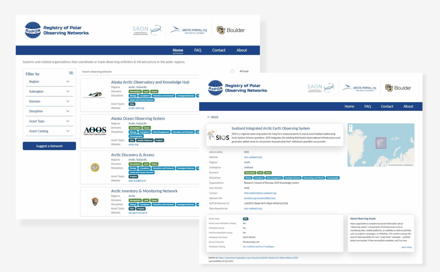
Understanding the landscape of polar observation requires a clear picture of the organisations, infrastructure and activities behind it. The Registry of Polar Observing Networks (RoPON) addresses this need by c I think we should use the text that Bill wrote: RoPON, is a catalog of systems and related organizations that coordinate or track observing activities and infrastructure across the Arctic, Antarctic, and Southern Oceans. onnecting previously dispersed information about systems coordinating scientific monitoring across the Arctic, Antarctic and Southern Ocean.
Developed jointly by Arctic Portal, the Sustaining Arctic Observing Networks (SAON) initiative and the University of Colorado Boulder, with funding from SAON and the NOAA Global Ocean Monitoring and Observing (GOMO) Arctic Research Program, RoPON helps users discover these networks, explore their coverage and access related resources.
Platform Development and Data Management
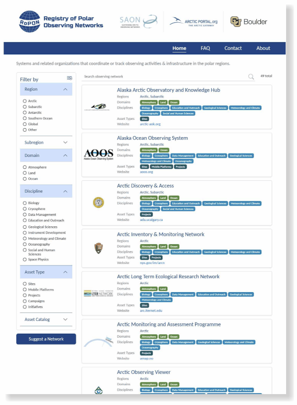
Each registry entry presents a network’s scope, geographical extent, contacts and associated data repositories, alongside details on access to inventories of observing assets. Its database, systems architecture and user interface Each observing network is presented with a description, link, and contact information – along with observational scope, spatial extent, related organizations, and associated data repositories. Also shown is whether the network has an inventory of observing assets (such as sites, mobile platforms, satellites, projects, campaigns, and initiatives), whether that inventory is publicly available, and if so, how to access it. have been refined through user feedback and a structured metadata model, supporting the organisation and presentation of this material.
A dedicated dashboard enables authorised representatives to maintain their own entries, while visitors can suggest additional networks through the homepage. This distributed approach supports the registry’s continued expansion and gives participating organisations an active role in keeping their details up to date.
Supporting Coordination and Practical Use
RoPON serves a broad range of users:
- Science planners and funding officers can assess coverage, overlap and gaps to help avoid duplicated effort.
- Network and facility managers can identify opportunities to co-locate activities and optimise limited resources.
- Researchers can discover relevant facilities and projects and explore potential collaborations.
- Data managers can locate repositories and support the alignment of datasets across networks.
- Educators and community members can explore polar observing initiatives, identify resources for learning and discover monitoring efforts taking place nearby.
Through this collaboration, Arctic Portal supports the development of digital tools that connect polar knowledge and make it easier to use, helping turn fragmented records into a shared resource for research and planning.
POSH - Polar Observing Site Hub
POSH - Polar Observing Site Hub
Arctic Portal contributed to the development of the Polar Observing Site Hub (POSH) in collaboration with the Sustaining Arctic Observing Networks initiative (SAON) and the University of Colorado Boulder, with initial funding from the NOAA GOMO Arctic Research Program. This collaboration reflects our work in connecting polar information resources and making them more accessible to research, planning and wider public use.
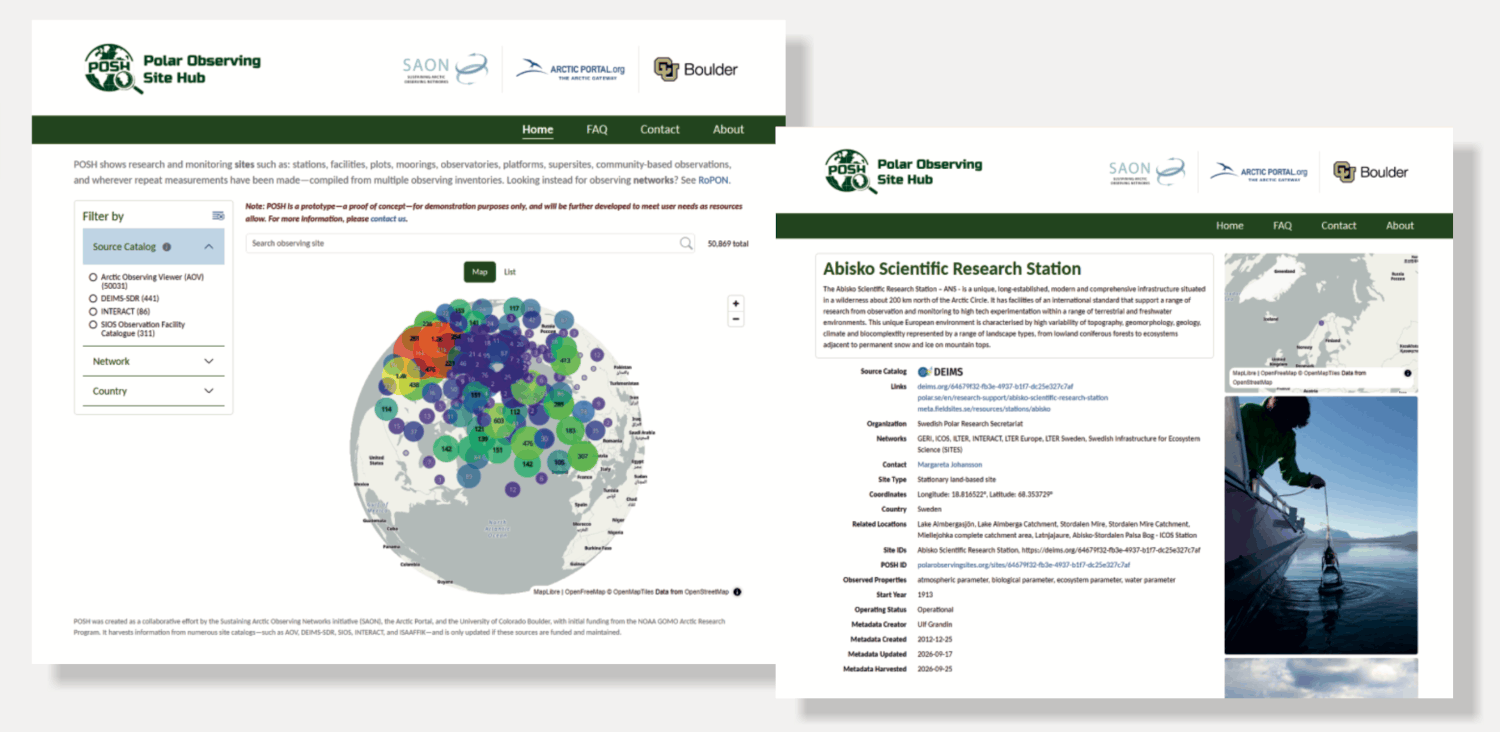
POSH compiles details from multiple observing inventories for over 50,000 research and monitoring sites, providing a more comprehensive view of where and how observations take place across the polar regions. These include research stations, observatories, facilities, plots, moorings, platforms and community-based observations, as well as other locations where repeated measurements have been collected.
Connecting distributed observing information
POSH aggregates structured site information from four authoritative inventories: the Arctic Observing Viewer (AOV), DEIMS, INTERACT and SIOS. Each site entry can include its location, name, description, organisation, contact details, associated networks, observed properties and links to data.
By bringing this information together through a single interface, POSH enables users to search across multiple inventories and dozens of networks without navigating each resource separately. The platform links back to the original catalogues, preserving their role as authoritative sources and relying on their continued maintenance and support.
Supporting research, coordination and resource planning
Access to connected site information supports a range of practical needs:
Science planners can assess observing coverage and identify gaps or overlaps, while network and logistics managers can explore opportunities to coordinate activities, share facilities and optimise limited resources and Funding organisations can better assess potential duplication of effort. For researchers, POSH helps identify relevant facilities, projects and data sources, establish collaborations, and locate observations that can support the calibration and validation of satellite imagery. Community members can also discover observing activities nearby and explore opportunities to engage with the initiatives and information collected in their regions.
Building towards an integrated discovery portal
As a prototype, POSH brings together metadata from different observing inventories and aims to include more sites as resources allow. It complements RoPON by focusing on individual research and monitoring sites, while RoPON provides information about the networks and organisations behind them. Together, they support SAON’s efforts to make observing metadata easier to find, access and reuse, in line with the FAIR principles.
