Governance & Arctic Organizations

Governance & Arctic Organizations

The Arctic region, with its pristine landscapes and abundant resources, is an area of opportunities and threats! The region is increasingly capturing the world's attention due to the effects of climate change, the societies, the environment, and its economic importance and potential.

To effectively manage this remote and environmentally sensitive area, a complex web of governance structures and organizations has evolved, each playing a crucial role in shaping the future of the Arctic. The Arctic Council is the leading one; the intergovernmental forum promotes cooperation, coordination, and interaction amongst the Arctic States and its inhabitants. Various other organizations play a vital role in governing in the Arctic.

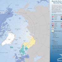
Arctic governance, as depicted in our informative maps and our governance section, presents a complex tapestry of international agreements and cooperation mechanisms aimed at addressing the unique challenges of this polar region. The maps visually highlight the roles and responsibilities of key organizations, such as the Arctic Council, IMO´s International Code for Ships Operating in Polar Waters, and the North East Atlantic Fisheries Commission (NEAFC)

The maps are often provided in various combinations of information and data, both in this section and other sections (for instance Arctic Summer Sea Ice extent and “Arctic definitions”).

A wide selection of our maps is available for viewing, subject to our specified conditions, and can also be purchased for direct download and can then be used for open publication on the condition that the source Arctic Portal is cited.

For any further information, if you need maps with different data-set combinations than currently available on our website, or need an even higher resolution or different definition, please contact info at arcticportal.org.

Arctic Council Member and Observer StatesZIP

Arctic Council Member and Observer States

This map shows the Member and Observer states of Arctic Council.

© Arctic Portal 2006-2026

Arctic Council Member StatesZIP

Arctic Council Member States

This map shows the Member states of Arctic Council.

© Arctic Portal 2006-2026

Arctic Council Members, Observer States and ObserversZIP

Arctic Council Members, Observer States and Observers

This map shows the Members, Observer states and Observers of Arctic Council.

© Arctic Portal 2006-2026

Arctic Council Observer StatesZIP

Arctic Council Observer States

This map shows the Observer states of Arctic Council.

© Arctic Portal 2006-2026

Arctic StatesZIP

Arctic States

This map shows the Arctic States that have territory within the Arctic Circle. These states include Canada, Denmark (via Greenland and the Faroe Islands), Finland, Iceland, Norway, Russia, Sweden, and the United States (via Alaska).

© Arctic Portal 2006-2026

Barents Euro-Arctic Council (BEAC) and the Barents Regional Council (BRC) members and observersZIP

Barents Euro-Arctic Council (BEAC) and the Barents Regional...

This map shows the Barents Euro-Arctic Council (BEAC) and the Barents Regional Council (BRC) members and observers.

© Arctic Portal 2006-2026

Exclusive Economic Zones of the ArcticZIP

Exclusive Economic Zones of the Arctic

This map shows the Exclusive Economic Zones (EEZs) of the Arctic.

© Arctic Portal 2006-2026

Exclusive Economic Zones of the Arctic with colored zonesZIP

Exclusive Economic Zones of the Arctic with colored...

This map shows the Exclusive Economic Zones (EEZs) of the Arctic with colored zones.

© Arctic Portal 2006-2026

International Code for Ships Operating in Polar Waters (IMO - Polar Code)ZIP

International Code for Ships Operating in Polar Waters...

This map shows International Code for Ships Operating in Polar Waters (IMO - Polar Code).

© Arctic Portal 2006-2026

International Code for Ships Operating in Polar Waters (IMO - Polar Code) and SAR delimitation in the Northern Circumpolar RegionZIP

International Code for Ships Operating in Polar Waters...

This map shows International Code for Ships Operating in Polar Waters (IMO - Polar Code) and Search and Rescue (SAR) delimitation in the Northern Circumpolar Region.

© Arctic Portal 2006-2026

International Code for Ships Operating in Polar Waters (IMO - Polar Code) with Sea Ice Extent 2022ZIP

International Code for Ships Operating in Polar Waters...

This map shows International Code for Ships Operating in Polar Waters (IMO - Polar Code). It also shows Sea Ice extent for February and September 2022.

© Arctic Portal 2006-2026

North Atlantic Treaty Organization (NATO)ZIP

North Atlantic Treaty Organization (NATO)

This map shows the North Atlantic Treaty Organization (NATO) member countries. At present, NATO has 32 member countries called NATO Allies, they are sovereign states that come together to discuss political and security issues and make collective decisions by consensus.

© Arctic Portal 2006-2026

North-East Atlantic Fisheries Commission (NEAFC)ZIP

North-East Atlantic Fisheries Commission (NEAFC)

This map shows the North-East Atlantic Fisheries Commission (NEAFC) convention and regulatory areas. Managing Fisheries in the North East Atlantic.

© Arctic Portal 2006-2026

North-East Atlantic Fisheries Commission (NEAFC) with EEZsZIP

North-East Atlantic Fisheries Commission (NEAFC) with EEZs

This map shows the North-East Atlantic Fisheries Commission (NEAFC) convention and regulatory areas. Managing Fisheries in the North East Atlantic. It also shows the Exclusive Economic Zones (EEZ).

© Arctic Portal 2006-2026

×