
News
Rock and roll satellite
ESA’s ice satellite is collecting data in the two poles, and the project is going well. The satellite is to give precise measurements of the vast ice sheets that blanket Greenland and Antarctica.

Since its launch 18 months ago, CryoSat-2 has been collecting data to improve our understanding of the relationship between ice and climate, according to ESA website.
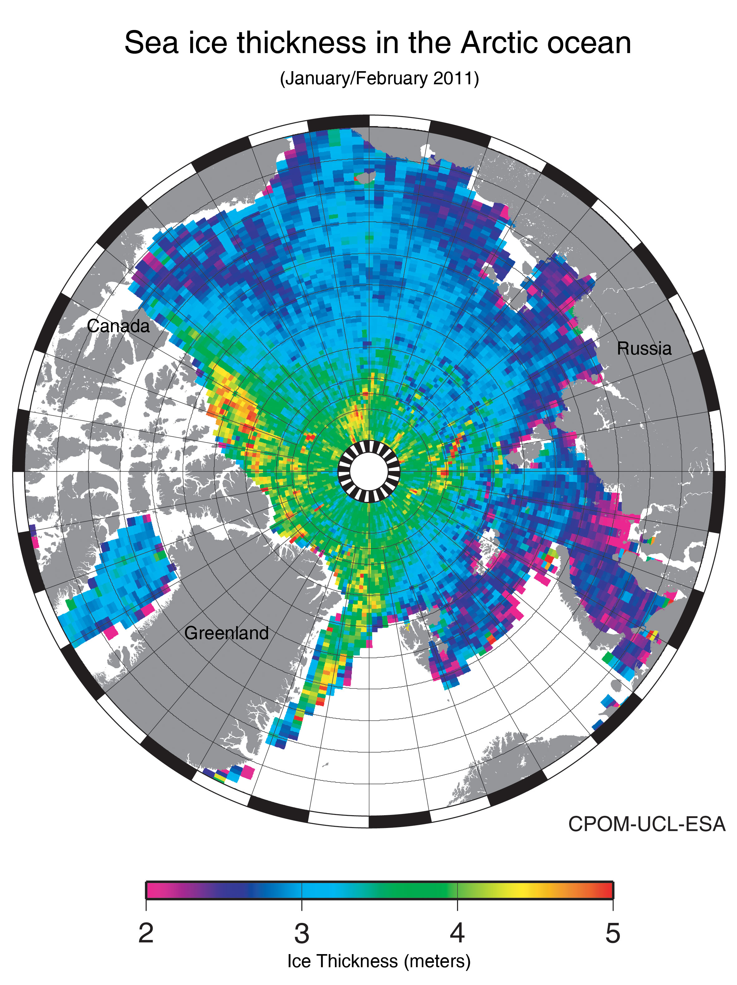
For the first time a map of the Arctic sea-ice thickness was released, by ESA. The ice-satellite is to thank for that map and it is still colleting data.
To ensure the precision of the measurements, an operation is under way to roll the satellite from side to side as it flies over the flat oceans. This maneuver is to calibrate CryoSat’s radar altimeter for measuring ice thickness, especially over the margins of ice sheets.
The altimeter has two antennas mounted on a bench about a meter apart. When it is working in the ‘SARIn’ mode, both antennas are used in parallel: one emits a signal and both receive the signals that bounce back.
Normally, this bench is parallel to Earth’s surface. But at the edges of the ice sheets, the ice surface is not always flat and the slopes affect the return signals.
Harsh conditions in space – with huge temperature differences between Sun and shade – can lead to the deterioration of CryoSat’s instruments, which can also lead to measurement errors.
In order to quantify these errors, ESA ground controllers are working to recalibrate the altimeter.
They are rolling the satellite to simulate the ice slopes and holding it in this position for several minutes. This must be done while CryoSat is over large, flat surfaces. For satellite altimeters, oceans are Earth’s largest flat surfaces.
It will also check whether errors are related to CryoSat’s varying thermal conditions – like when exposed to the Sun or in the shade.
“With the results from the different sets of rolls over different ocean surfaces and at different ambient conditions, we are aiming to characterize the instrument to a precision better than we thought we could make at the time of the launch,” said Tommaso Parrinello, CryoSat mission manager.
During several maneuvers on Monday and Tuesday, the satellite is rolling 0.4º to both sides while over the Indian and Pacific oceans, before returning to its original position.
“The preparations for the roll activities have been quite challenging,” explained Nic Mardle, spacecraft operations manager.
“Although we had experience of these activities from the commissioning phase, we had to iterate a few more times with the planning and mission control teams so that we could support exactly what was required.”
Satellites have already shown that the extent of sea ice in the Arctic is diminishing. In fact, this year’s minimum has set a new record low.