
News
New Arctic Maps Now Available on Arctic Portal
Arctic Portal is pleased to announce the latest addition to our online resources, an expanded collection of Arctic maps that provide valuable insights into the region’s geography, sea ice extent, and varying definitions of the Arctic.
These new maps enhance our ability to visualize and understand the dynamic changes occurring in the Arctic.
Our latest update includes:
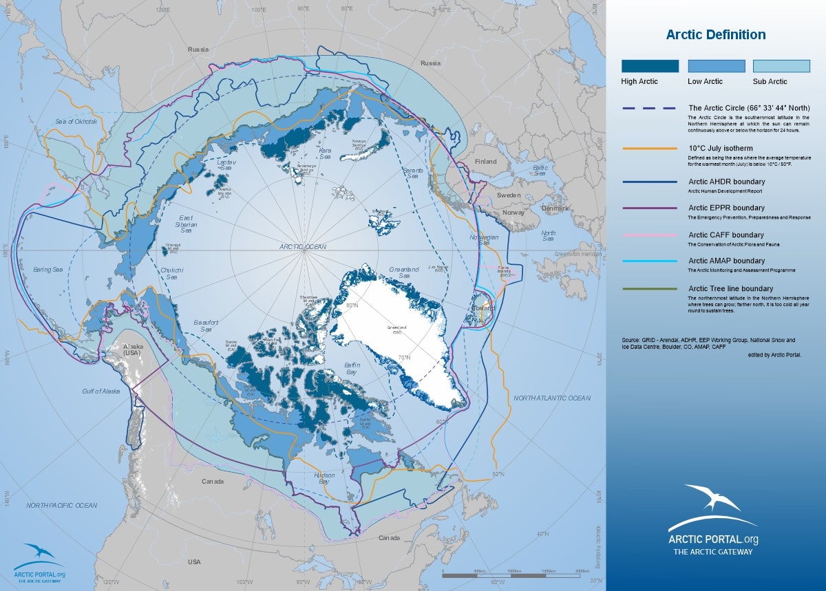
Arctic Definitions Combined with Four Projections: We have updated the Arctic Definitions Combined map and added more projections displaying Arctic definitions across four distinct projections: North Polar Europe, North Polar Bering, North Polar Canada (see map), and North Polar Russia.
These projections offer diverse perspectives on the Arctic and aid in comparative studies of regional boundaries.
Arctic Sea Ice Deposits at Annual Maximum and Minimum: Our collection now includes sea ice extent maps for February (annual maximum) and September (annual minimum) for the years 2023 and 2024.
These maps illustrate seasonal variations in ice coverage, providing crucial data for researchers, policymakers, and the general public.
 Comparative Sea Ice Extent (2012-2024): A newly developed map compares Arctic sea ice at its annual minimum in September across multiple years, 2012 (the lowest recorded sea ice extent), 2019, 2020, 2021, 2022, 2023, and 2024. This comparative visualization highlights long-term trends in Arctic ice loss and its potential implications.
By expanding our collection of maps, Arctic Portal continues to provide high-quality, accessible data for those interested in Arctic research, climate change, and regional development.
These resources are now available on our website, free for use in low resolution for higher resolution please visit our Map Store. If you require other specific maps, such as a combination of different data layers, please contact
To explore the newest maps, please visit the Mapping Gallery.
Arctic Portal Map Gallery
Arctic Portal specializes in creating customized graphical maps that cover a range of significant Arctic topics of Global importance and recognition. The Arctic Portal Map Gallery includes a wide selection of our custom maps. The maps cover a variety of topics of highest relevance, divided into the following categories: Arctic definitions, Arctic Sea Ice, Shipping, Governance & Arctic Organizations, Arctic Flora, Arctic Fauna, Infrastructure, Environment and Arctic Countries and Islands.
We are continuously working on new or improving the maps in our Gallery. All the data employed in crafting our maps is sourced from the most reliable and reputable databases currently available. Our commitment to transparency ensures that sources are consistently cited.
The tags below provide an opportunity to view previously posted related news within the selected category