
News
Major volcanic eruption likely soon in Iceland!
The Icelandic Met Office has officially declared the cessation of the eruption at Litli-Hrútur on Reykjanes by Reykjavík, which started on July 10th.
Mother Earth is however warning the inhabitants with ongoing distributed seismic events, land uplift, and increased thermal activity that major volcanic activities could happen again soon in Iceland. The uncertainty is greater than before as the registered activity is spread widely throughout the island.
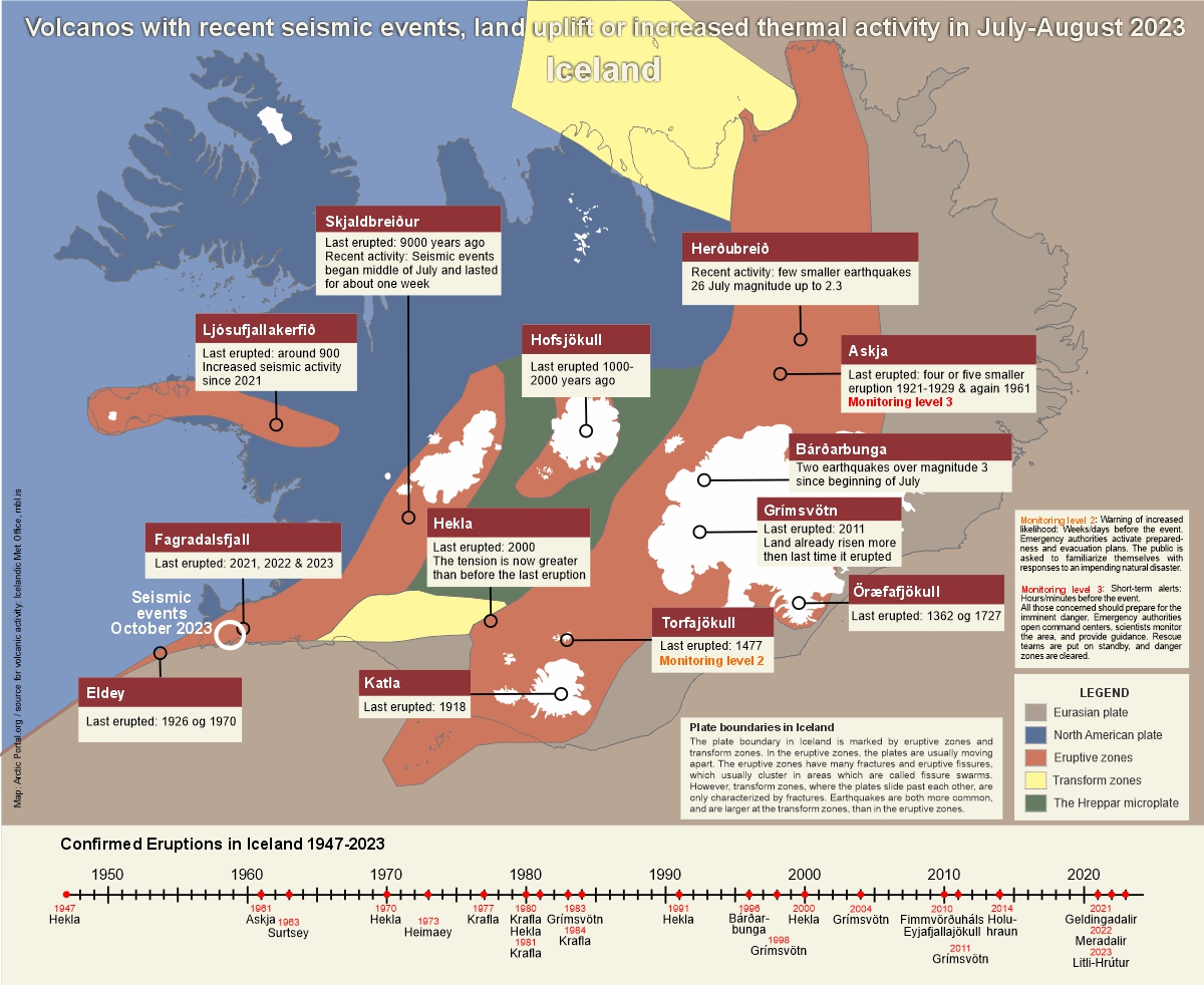
Significant volcanoes like Askja, Torfajökull, Grímsvötn, and Bárðarbunga are showing signs that they are “waking up” with significant land rise being reported. Transformative seismic processes are also being measured at sites such as Skjaldbreiður, Katla, Hofsjökull, and Eldey, while the expanding dimensions of Hekla allude to its gradual buildup towards a future eruption.
For a closer view of these developments, the map above provides insight into recent activities and the geological structure in Iceland.

Amidst these geological dynamics, Torfajökull has garnered attention from the Icelandic Met Office. Notably, the terrain has lifted up by four centimeters in just two months, signaling magma accumulation and expansion within the volcano. Volcanologist Þorvaldur Þórðarson underscored this phenomenon as the volcano's self-reminder of its active nature, potentially leading to eruptions at its own discretion.
In the realm of uncertainty lies Askja, with a recorded land uplift of approximately 70 centimeters since 2021. Recent deliberations within the North East's police concluded that no immediate further measures or access restrictions were warranted for now at least. Land uplift has also been measured by Bárðarbunga but conclusive signs of imminent eruptions remain relatively weak.
Notably, Hekla, a prominent geological feature, continues to expand as affirmed by new ground slope measurements presented during the weekly Institute of Geosciences meeting. Geophysicist Halldór Geirsson, who led the meeting, speculated that this expansion portends a more vigorous eruption compared to the last occurrence. The expansion trend in Hekla has persisted since its last eruption in 2000.
Historically, Hekla eruptions have been spaced between 50 to 100 years; however, a paradigm shift occurred after a substantial eruption in 1947, leading to more frequent outbursts. Halldór Geirsson emphasized that Hekla's eruptions are typically accompanied by short notice periods, underscoring the dynamic and unpredictable nature of these events.
Plate boundaries in Iceland (see on map)
The plate boundary in Iceland is marked by eruptive zones and transform zones. In the eruptive zones, the plates are usually moving apart. The eruptive zones have many fractures and eruptive fissures, which usually cluster in areas which are called fissure swarms. However, transform zones, where the plates slide past each other, are only characterized by fractures. Earthquakes are both more common, and are larger at the transform zones, than in the eruptive zones.
Source:Icelandic Met Office, mbl.is
The tags below provide an opportunity to view previously posted related news within the selected category