
News
Arctic sea ice reaches minimum extent for 2014
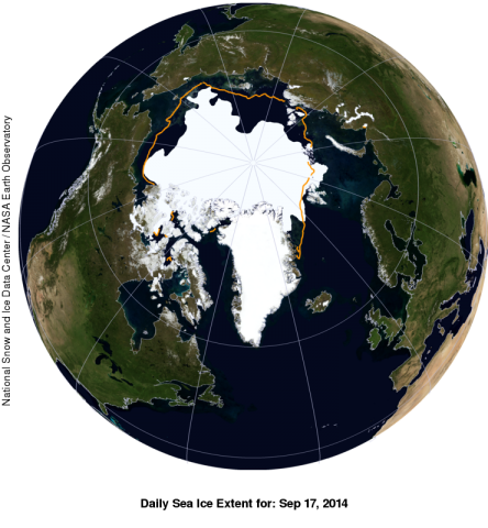
The Arctic's sea ice cover appears to have reached its minimum extent on September 17, 2014. Sea ice extent on that day was measured at 5.02 million square kilometers (1.94 million square miles). It was the sixth-lowest extent recorded since satellites began measuring sea ice in 1979. The number is above the 2012 record extent but is still below the long-term average.
Sea ice extent in Antarctica, where it is late winter, has surpassed the satellite-era record for maximum ice extent. We will report the 2014 Antarctic maximum sea ice extent and date of maximum in October, since it may still continue to grow for a short while.
The Arctic sea ice extent number is preliminary—changing winds could still push the ice extent lower, clarifies National Snow and Ice Data Centre.
NSIDC will issue a formal announcement at the beginning of October with full analysis of the possible causes behind this year's ice conditions, particularly interesting aspects of the melt season, the set up going into the winter growth season ahead, and graphics comparing this year to the long-term record.
Source: National Snow and Ice Data Center
(Source: NASA.gov) Arctic Sea Ice, Summer 2014